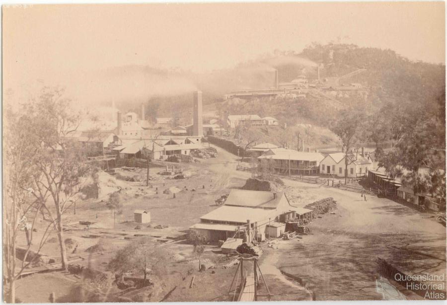
The year 1872 opened with the important discovery of minerals – tin in Stanthorpe (beginning of great tin rush) and copper in Mount Perry. Mineral selections were taken up with such rapidity and so numerously that the services of surveyors were at a premium. There were not enough surveyors in the colony to meet the necessities. In this situation the Surveyor General, seeing me in attendance at the Lands Office, approached me with the inquiry whether I would re-enter the field and conduct the mineral surveys at Mount Perry.
As a matter of course my first step was to consult the Under Secretary and the Minister for Lands, who had made arrangements for my permanent appointment in the service. They expressed themselves fully satisfied that my call as a surveyor was an exigency, and that if I entered upon the work it would not prejudice any re-entrance in the the service when the surveys were accomplished. The Minister for Lands made a note in his own handwriting to this effect and I accordingly entered upon the surveys. In doing so I forthwith rose out of obscurity, former acquaintances who had seemingly forgotten my existence suddenly renewed their acquaintance – no doubt because their selections would be surveyed by me.
The change in my prospects was very welcome after four years of struggling and precarious occupations out of which I had only one steady year of work in the survey of Conchin. Yet even then the protracted wet weather had been a serious loss, actually burdening me with debt, which I was working down out of the salary of 8 pounds and 6 shillings a month which I had been receiving as supernumerary in the Lands Department. I had had, however, the satisfaction of the Surveyor General, who told me that the manner in which I had completed surveys at Conchin had led him to select me for the mineral surveys of Mount Perry
The mineral surveys kept me actively employed for eighteen months and proved a run of good luck that enabled me to matters of history all my indebtedness through past drawbacks, and likewise furnished the means of procuring equipment in horses and gear and the general paraphernalia of camp appendages which comprise all the comforts and charms of the gypsy life of a surveyor.
My survey through the district of Mount Perry, taking in the large scope of the Barnett River watershed, revealed the latent potentialities of a part of Queensland as full of interest as my observations in the survey of the watershed of the Brisbane River.
The preliminary interest that bought it into notice was the discovery of copper, which sufficed to implant an extension of population. In taking a birds eye view of the locality, the good condition of cattle and horses, and the fertile valleys on the banks of the water courses evidenced by the successful result of culture wherein the old residents had planted fruit tress, were indisputable evidences which indicated a great producing area in the future.
The country differed in geological character from that of the Brisbane River and was much rougher; but the hills were undoubtedly superior grazing tracts. For dairying enterprise the rich valleys were capable of producing fodder in abundance so that with the facilities for irrigation and the local resources equaled the richest gold mine that could be found.
My travels around the Mount Perry district kept me in frequent correspondence with the Lands Department and the Under Secretary for Lands, who was also Chief Commissioner of Crown Lands. He, comparatively speaking, was a Surveyor General over the pastoral territory of Queensland; for the department business of runs of the colony being vested in him, he required plans of their boundaries, and accordingly gave instructions for the survey of all runs. It happened at the time of my mineral surveys of the Burnett that some sixty miles of the Burnett River had remained unsurveyed. As a result of my frequent intercourse with the Under Secretary he was evidently reminded, as Chief Commissioner of Crown Lands, that this portion of the Burnett required survey.
The instructions for survey were accordingly sent to me and the survey affected in due course, enlarging my experiences in Queensland and the revelation of its latent potentialities as I passed over the rich lands of Dogilbo and the conterminous runs, each of which had their cultivation patches and in most cases well bearing fruit trees as object lessons pointing to future resources.
The result of my survey proved very satisfactory and led the way for the Chief Commissioner to entrust me with further responsibilities; for he acquainted me that he proposed to place in my hands the unsurveyed rivers and watercourses of the Gregory South and Warrego district. Shortly afterwards I received instructions which directed me to survey the Langlo, Paroo and Bullo rivers from their head to the boundary of New South Wales as well as Coopers Creek from the junction with the Barloo to the South Australian border.
My surveys in Mount Perry having proved financially advantageous enabled me to gather a respectable equipment which I looked upon with satisfaction of the proud possessor as I reviewed myself the owner of six horses, spring cart and harness and an outfit of camping gear all paid for. So confident was I of success of opening a new chapter of my evolution that I embarked my very last shilling after having my home provided for some months. I undertook the responsibility of engaging four assistants and traveled 500 miles to reach the starting point of my surveys.
